Day 37 - Polkerris to Polperro – 13 miles
I woke up in the tent really early again. Some time before 6am in fact but slumbered until about 6.40am. I got up and showered and had cereals for breakfast. I made sandwiches for the day. The sky looked ok... bubbly high clouds, but little in the way of sunshine and it was really chilly in a strong breeze again.
I put the bike on the back and set off before 8am as it was a much longer drive to drop the bike off at Polperro. It would also involve crossing the river at Fowey twice. I also needed to get petrol and withdraw some more cash as I'd only paid for two nights initially when I arrived at the campsite and I'd decided I would move tomorrow instead.
I drove up Pentewan Valley to St Austell and called in at the Asda to get petrol from the card only petrol station and also to withdraw cash. I carried on and drove back through Par and past Polkerris to get to the Ferry across the river to Boddinick. It was quite exciting. Not the run of the mill drive to drop the bike off for a change. I had to wait for the ferry to come across, but it wasn't long. Safely crossed, and much much quicker than going all the way around the estuary, I made my way down the lanes to Polperro, taking note of the hills and the route for the bike ride later on. I chained the bike up in a service area to a signpost and then made my way back to Boddinick to cross the river again. £2.70 x 2 down the drain, but a fun way to spend money. I'd be doing the ferry again later in the day, but at least it only costs £1.20 with the bike!

Waiting for the Boddinick ferry at Fowey to land.
I made it back to Polkerris car park for 9.45am, so not a very early start considering it was a longer planned walk today. Oh well.. couldn't be helped after all! The car park charge wasn't too bad.. £2.50 for all day I think? I set off down the lane to the tiny harbour and then set of up the coast path down the side of the Polkadot Cafe where I'd had my Diet Coke yesterday. It was a steep zigzag up out of the valley, but pleasantly through trees, which sheltered me from the worst of the wind, which was rather strong and chilly. At the top I took to the cliff path which was totally exposed to the south westerly wind as I made my way out to Gribbin Head. Not far along the path a jogger overtook me with a mad Jack Russell running along with him that barked and snapped at me despite a pathetic 'Charlie' from the bloke and a 'Sorry about that' TWAT! As he overtook the first spots of rain of the day arrived. I have to say the sky was now quite lowering and didn't look like it was going to be any better than yesterday if not worse! So much for the forecast of occasional showers with plenty of sunshine between. I don't think I'd had any of that yet!

Looking back over Polkerris to Par Sands after the climb up through the trees.

Jogger as I start out along the cliff path to Gribbin Head 'Charlie' is probably gnawing at my ankles.

Looking back at Par Sands from near Gribbin Head.

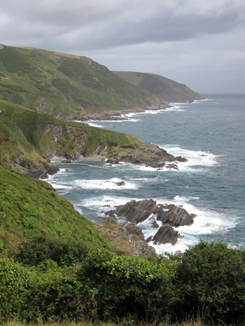
The view ahead to Little Gribbin with Dodman Point right across St Austell Bay.
I got out to Little Gribbin that I thought was the real Gribbin Head at first, with its little beach below and the wind blasting straight across the bay from Dodman Point. The jogger came back and Charlie snapped and barked around my ankles again.. sigh! There was another much larger beach and bay before Gribbin Head itself and the path took me up to the large Gribbin Daymark tower with its red and white stripes. I took a wrong path to start with which annoyed me but I walked back up to the Daymark and then headed downhill towards the series of small bays that make up Polridmouth. From Gribbin Daymark the whole day was a wonderful stretch of the whole Way. I suppose the scenery was helped by the strong southwesterly wind causing a good swell on the sea, so that all the way along, the waves were roaring and frothing on the rocks below me. The dramatic squally showers also added interest and atmosphere, with dramatic clouds dragging heavy veils of rain beneath them from across the bay towards Dodman Point.

Small beach sheltering behind Little Gribbin.

Looking from Little Gribbin across St Austell Bay to my start point yesterday of Pentewan and Black Head.

Looking across the larger beach of Platt before Gribbin Head itself and the Gribbin Daymark Tower.

Ship out to sea from Gribbin Head.

The bays of Polridmouth and the entrance to Fowey beyond as I descend from Gribbin Daymark Tower.

Polridmouth and Southground Point beyond it.

Looking back at Gribbin Daymark Tower as I near Polridmouth.

Gribbin Head from Polridmouth beach.
I sat for a while on the sea defences at Polridmouth bay proper and ate one lot of my sandwiches. I was struggling today. I was already tired and was developing a blister on my right big toe by the feels of it. This was not good as I was still miles and miles away from Polperro. It seemed a long way to Fowey even as far as I was concerned!
I set off again up the cliff path around to St Mary's Castle in Fowey. Another heavy shower cascaded down again as I arrived and I sheltered under my trusty umbrella again as I waited for it to pass while looking out at a small beach at the seaward end of the estuary. I walked along past all the houses until I came to the sign to the passenger ferry over to Polruan. How many times am I going to pay to get over this river today?? I didn't have to wait long for the ferry as it was on its way back over to the waiting passengers and me from the Polruan side. We all got on and took the 5 min trip across to Polruan harbour. I went into the post office and bought a Solero ice cream and a bottle of Diet Pepsi as a treat to give my energy levels a bit of a boost.

Looking back across Polridmouth Bay to Gribbin Head from Southground Cliffs.

Polruan on the far side of the Fowey Estuary and the headlands to be rounded during the afternoon, from Southground Cliffs.

The entrance to Fowey after rounding Southground Cliffs.

Polruan across the Fowey Estuary from near Coombe Haven.

St Catherine's Castle on the Fowey Estuary with Polruan beyond.

Polruan across the Fowey Estuary from near St Catherine's Point.

Looking back at Fowey from the ferry across to Polruan.
I found the coast path along a street just back from the harbour and set off again. Another heavy shower appeared as I climbed out past the outskirts of the town. From this point on the showers became a bit annoying for a while as there seemed to be far more of them than the sunshine between! At least the climb out didn't seem as bad as it had looked from the other side of the estuary. There was a good view out back over the estuary from the castle ruin and coastguard hut at the top.

View back over to Fowey from Polruan harbour.

Castle ruin and coastguard lookout after initial climb out of Polruan.

View back over Fowey Estuary from near Coastguard Lookout above Polruan.
From this point on the coastal scenery was lovely, especially heading around the back of Lantic Bay with its beach and crashing waves on the far side. There was a big climb up to then head out along Pencarrow Head. In fact there were an awful lot of steep ups and downs along this section. I was really weary, and the toe was a bit sore, but I didn't really mind as the beautiful scenery was more than reward enough for my pains!

Looking back at Gribbin Head from near Washing Rocks.

Great Lantic Beach sheltering by Pencarrow Head across Lantic Bay.

Great Lantic Beach.

Looking back as I round Lantic Bay, Dodman point still visible a long way away.

Looking back across Lantic Bay and beyond to Gribbin Head as I walk out onto Pencarrow Head.
After Pencarrow Head it was a lovely walk around Lantivet Bay even though there were numerous serious ups and downs, especially at West Coombe and East Coombe. As I climbed out of East Coombe I passed another daymark. This time just a white tower. Odd that it was not placed at the top of one of the headlands rather than halfway up a valleyside??
I knew now that I wasn't too far from Polperro. There were a few more serious ups and downs. At the top of one I sat on a bench for a while and had some kiwi fruits for a bit more energy.

The way ahead after rounding Pencarrow Head.

Looking back along the rocks of Lantivet Bay. |
Sandheap Point, near West Coombe, Lantivet Bay. |

Looking back along Lantivet Bay cliffs to Pencarrow Head.

Pencarrow Head from Lansallos Cliff, Dodman Point beyond half hidden by a heavy rain shower.

Near East Coombe Lantivet Bay.

The white daymark half way up the climb out of East Coombe, Lantivet Bay.

Another shower heading my way as I sit eating kiwi fruit looking out across Pencarrow Head, Gribbin Head and beyond.

Small natural arch as I get nearer to Polperro.

Rocks and waves as I get nearer to Polperro. |

View all the way back to Dodman Point. |
At last the final mile or so became flatter along Chapel Cliffs. As I arrived at the harbour itself in Polperro the rocks were humming with tourists. I expect its only natural as the place truly is chocolate box Cornwall. I took a few photos and then headed down to the harbour side, ignoring the temptation of a pint in The Blue Peter as I made my way down.

Final approaches to Polperro, the white cross at the entrance visible at last.

First houses across the harbour in Polperro as I walk along Chapel Cliff.

Polperro and Harbour from Chapel Cliff.

Looking back at natural harbour entrance Polperro.

Boats and buildings in Polperro Harbour.

The end of the harbour at high tide Polperro.
I walked up the harbour side and then up the road to find the bike as I'd left it. I wasn't looking forward to the ride at all as I was really weary this evening. The ride up the main street to the car park was a gentle climb and not a worry at all. I then turned up the Lansallos road at the mini roundabout by the car park and the first real climb began in earnest. I did cycle all the way up but in truth stopped twice or thrice on the way up to catch my breath. Even at the top of the steepest rise the road continued to climb for a mile or so until at last the middle section of the ride was reached which pretty much a slight downhill for a couple of miles or more.
There was another climb up as I neared Boddinick before the inevitable cycle back down to the ferry itself. I had to wait for the ferry again which was full of cars from the other side. There was only 4 cars on it from my side when it set off.
And so began the last final climb of the day.. a long drawn out climb up to the traffic island and then alas still uphill for a good while afterwards! I stopped at a petrol station not long after the road island, in desperation for a rest but also to get some more Diet Coke and some snack or other for my tea. I ended up with some chicken bites and a bag of quavers. I was sweating buckets while actually buying them.. quite embarrassingly in fact! I sat outside for a while to recover and then set off uphill yet again until at last I reached the turning off to Polkerris. I made it back to the car at about 7pm. A very long day and I still had to drive all the way back to the campsite.
I had a shower straight away when I got back as I'd been dripping all day on and off as I'd sweated my way up the huge cliffs and also on the cycle ride back to Polkerris on those three big hills. I then went to pay for the night and then sat in the car to type up this and went to bed at about half nine.
I am planning to move campsites tomorrow, but may do a short afternoon walk just to say that I have continued my progress at least a little bit. Maybe do from Polperro to Looe or something? Though the forecast isn't brilliant again for the afternoon. Sigh.
Map of the day's walk:(click to enlarge)


Comments
Post a Comment